Thursday 23 November 2017

Mamcala

Last May I blogged about climbing Skirrid in the Black Mountains. Dru Marland, who regularly enthrals me with stories of her life on the Kennet & Avon Canal, left a comment about Raymond Williams' books "The People of the Black Mountains". Six months later I'm only half way through the second book in the series but fine fare should, I contend, be consumed slowly and thoughtfully.

Fifteen times in book one, Raymond Williams mentions a great cave. Here's the first, from the time when the last Ice Age was still receding:
There is also the story of the great cave, of Mamcala, where the sacred fire always burns. For the fire to burn men must kill and eat.

And later in the book:
'We heard the drum,' Tarc said. 
'It is the hunters of Mamcala. They are in the forest above us.' He pointed up to the hill on the other side of the river. 

Caves... forest... hills... Like so many places in the book – such as Broken Mountain (Skirrid) and Curve River (River Wye) – I felt that I ought to know this one, and at the end of the book my suspicions were confirmed. It was King Arthur's Cave, high above the River Wye near Symonds Yat, on one of my favourite walks.


I'm rather pleased with this photo, taken today in Autumn sunshine that just appeared from behind the clouds at the right time. It really is a beautiful spot.


I apologise for looking as if I'm on sentry duty, guarding the cave from the hunters of Mamcala. Obviously it's a role that I feel necessary to fulfil for here I am, back in 2013... Relax, Angie dear, relax!


This is my good friend Lucy, exploring the cave depths during a recent visit. Sooner or later, all my friends get dragged off to this spot!

Though "The People of the Black Mountains" is a work of fiction, it is solidly based on facts that have been gleaned through decades of archaeological research. Probably the first person to seriously investigate these caves was the Revd William S Symonds. In his 1872 book "Records of the Rocks"  he tells of  the well-known cave dweller of modern days, "Jem the Slipper", under whose guidance I first visited the hyæna's den and the other caves. Were Jem around these days he would be welcoming a steady stream of visitors, including me on at least 6 occasions.

I used to think of Victorian amateur archaeologists as being little more than blundering treasure hunters. Certainly, they lacked the rigours demanded of modern-day archaeology, but Revd Symonds clearly took his work very seriously. Here's an extract from his book:

This Earth was about two feet in thickness. In it were discovered flint flakes and chips, with three pebbles unmistakably chipped by human workmanship. Two of these are of black chert, evidently formed from rolled pebbles, while the third has been chipped, and is a pebble of some Lower Silurian rock. I excavated with my own hands one of the cores of chert from which flakes had been struck, and the second was found by my companion at the time, Mr. Scobell. Associated with these were the teeth and jaw of a Bear, with those of the horse, and in Mrs. Bannerman's cave those of the
Beaver.


One lasting reminder of Revd Symonds' work is the heap of soil that he shifted to gain access to the caves. And somewhere here, near the large cave entrance, remnants were found of a hearth on which fires burned 12,000 years ago.

There is also the story of the great cave, of Mamcala, 
where the sacred fire always burns. 


Sunday 19 November 2017

The Gravy Boat

Vegetarians need not trouble themselves with this post, other than perhaps to say "I told you so." I write to my fellow omnivores.

Before July 2016 there was but one way in our household to make gravy for a roast dinner. No 'convenience' gravy granules here, dear me no. Instead we recovered the succulent meat juices from the roasting tin, poured them into a bowl, added a little flour to thicken and voila! Perfect gravy containing all the goodness of the meat. What could be better than that?

Well rather a lot, actually, and I have Slimming World to thank for enlightening me. Two tablespoons of that steaming liquid scored 15 syns – my allocation for a whole day. And who stops at two tablespoons of gravy? Not me! Reluctantly, we switched to the dreaded gravy granules. "All natural flavours," declared the tin, but in comparison to 'real' gravy the result was bland and uninteresting. So on the next Sunday I spiced it up a generous sprinkling of mixed herbs.  Not bad, not bad at all. Indeed, it was very tasty.

Slimming World has so changed my eating habits that I've never been tempted to revert to my old ways. Given the choice between 15 syns of gravy and 15 of fine wine, there really is no contest. However, last week S-- poured the juices from a gammon joint into a mug, set it aside with the intention of separating out the jelly from the fat....  and forgot about it.

This Saturday we found it again, languishing at the back of the fridge... and there at the bottom lay two and a half ounces (71g) of solid fat.  Half of that would have been mine. An ounce and a quarter of fat every week, and sometimes twice a week, week in, week out, raising my cholesterol level and furring up my arteries. Yuk!


Tuesday 14 November 2017

Old Maps (2): Lumps, bumps and slag heaps

Looking at old maps can be endlessly fascinating, but for me they become even more interesting when I can relate them to actual features on the ground.  Thankfully, there is now a website of old maps covering the whole country – courtesy, strangely enough, of the National Library of Scotland. They're happy for me to reproduce their maps, so long as I give them the credit so... "Hooray for the National Library of Scotland!"  On this example from an Ordinance Survey 1 inch map of 1896, I've zoomed in on a fairly nondescript area of the Forest of Dean. Let's see if I can bring it to life.


Here's a closer look at the area on a 25 inch map from about 1885. There, at the top, is the Rising Sun Beer House (BH) where I join the Ukes uv Azzard on Thursdays to play my ukulele. Incidentally, the pond, clearly shown on this map, is still there. Perhaps it marks the site of even older mine workings.


Here's how it looked in about 1905 – unfortunately not as clear as the earlier map. Bethlehem Chapel has gone – perhaps it was a little too close to the beer house – but Crown Colliery has appeared, together with some new railway tracks.  It's time to put on my walking boots and go exploring!


Firstly, an even closer look at the 1905 map, with my photo locations marked


1

2

3

4. The air shaft on the right (marked on map)
ventilates Moseley Green Tunnel
5
To add a finishing touch, I found this snippet of an aerial photo, taken in 1946. There still seems to be some activity around New Engine Colliery (centre left, known by this time as Brick Pit) but Crowns looks abandoned.


There are, of course, far more interesting places to explore on maps and on foot, such as nearby Parkend (shown below on a circa 1885 map), and doubtless your favourite corner of the Kingdom too. A nice feature of the National Library of Scotland site is that maps can be overlaid with modern Bing aerial photos, though this proved well nigh impossible to show here.

I wish you many hours of happy exploration.


Sunday 5 November 2017

The Isle of Man: a last look?

Glen Maye

I'd intended my post on October 7th to be the last about my holiday on the Isle of Man. But as I wrote, I realized that there was one more story to tell.

That, in a way, reflects the whole holiday, which was conceived as a once-in-a-lifetime visit. A friend declared that she had seen all there was to see on the island in four days. I can almost hear shouts of horror from islanders reading that last sentence but it did seem to suggest that a week would be more than adequate. Moreover, in 2019 I shall clock up my three score years and ten on this planet and with so many other places to visit, a return seemed unlikely.

On the last day of our holiday we decided to take the A27 road south of Peel and explore a little of the sparsely populated west coast. First stop was Glen Maye, where there is a pretty waterfall. As we admired the view we were joined by a guy who was walking his dog. I explained that we were on a 'last lap' of the island before boarding the ferry home. "Then don't miss Niarbyl," he advised. "It's just down the road from here."


Niarbyl mean 'The Tail'. I stood on the foreshore, gazed out across the bay toward that hilly tail, with the Calf of Man faintly visible in the distance, and knew that I didn't want to leave. The crowds in Douglas, the steam trains and the trams, were 14 miles away but it felt like 140, so peaceful was that spot.

A glance at the map showed that there was a rich, mountainous coastline to explore; much of it only accessible on foot... but no time in which to do it.  Indeed, the whole west coast had hardly been explored, save for the lovely town of Peel - our favourite on the island.

Peel, from Corrins Hill
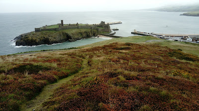
Peel Castle

"One day," I told myself, "I would love to return."